Kenya has about 10,000 wetlands
We have over 10,000 wetlands countrywide. NEMA is working to map out all wetlands-have a clear path on protection and restoration to enhance their sustainability and plant trees to contribute towards 15 billion tree planting initiative by 2032 ~ NEMA Director General, Mamo B. Mamo, EBS.
-
Wetland Mapping: The process of mapping out over 10,000 wetlands involves using advanced technologies such as satellite imagery, GIS (Geographic Information System), and on-the-ground surveys. This comprehensive mapping will allow NEMA to have a clear understanding of the distribution, size, and ecological significance of each wetland.
-
Protection and Restoration: With the mapped data in hand, NEMA can develop targeted strategies for the protection and restoration of wetlands. This may include implementing regulations to prevent degradation, monitoring water quality, and restoring damaged wetland areas. The goal is to ensure the long-term sustainability of these crucial ecosystems.
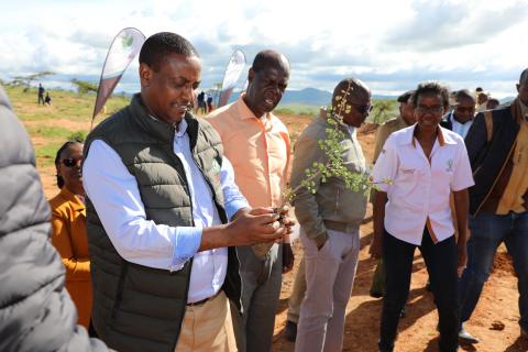
NEMA Director General, Mamo B. Mamo@NemaKenya leading a tree planting exercise at Maiyanat demonstration plot in Laikipia County. The 250 ha demo plot employs the use of semi-circular bunds and vallerani to enhance water retention to facilitate restoration of degraded landscapes to restore water sources and wetlands downstream
The @Nemakenya Chairman, Emilio Mugo appreciated the community for using indigenous knowledge to restore their degraded landscapes to facilitate water retention and reduce land degradation. The demo site acts as a catchment for the wetlands downstream. The chairman pledged the community that the Authority will plan to have the World Desertification and Drought Day next year at Maiyanat.
